Inês Cardoso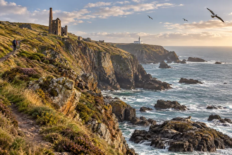
Cornwall’s coastline is not just beautiful scenery between beaches.
Walk for a few miles and you can pass an Iron Age fort, abandoned mine workings, a lighthouse built after a maritime disaster, grey seals sleeping beneath the cliffs, and peregrine falcons riding the wind above the Atlantic.
That combination makes the best Cornwall coastal walks for cliffs wildlife and historic sites much more interesting than routes chosen purely for photographs.
Some walks are short enough for a relaxed morning, while others cross steep valleys and exposed headlands that require several hours of serious hiking.
The South West Coast Path provides the backbone for many of them, but you do not need to tackle an entire long-distance stage. Circular walks around places such as Godrevy, Pentire and Dodman Point let you experience Cornwall’s landscape without complicated transport.
The key is choosing routes that offer different kinds of interest. Mix wildlife-rich headlands with mining landscapes, prehistoric sites and dramatic geological coastlines, and every walking day will feel completely different.
Godrevy to Hell’s Mouth for Seals and Huge Atlantic Cliffs
The Godrevy to Hell’s Mouth coastal walk is an excellent place to begin because it packs scenery, wildlife and history into a manageable route.
The National Trust’s circular trail covers about 5 miles or 8 kilometres and takes roughly two and a half to three hours. It is rated moderate, with rocky sections, some narrow paths and several steep climbs.
Godrevy Lighthouse dominates the opening scenery. Built in 1859 after the loss of the steamship Nile, it stands offshore on the Stones reef and remains one of the most recognisable landmarks in St Ives Bay.
Wildlife adds another reason to slow down. Grey seals frequently haul out around Mutton Cove, while the headland supports resident and migrating birds including pipits, wheatears, swallows and occasional peregrine falcons.
Bring binoculars and observe seals quietly from above rather than approaching the cliff edge.
Walk Pentire Point and The Rumps for Wildlife and Prehistory
North of Polzeath, Pentire Point and The Rumps provide one of Cornwall’s strongest shorter headland walks.
The National Trust’s main Pentire headland circuit is approximately 3.4 miles or 5.4 kilometres. The landscape includes coastal grassland, wide views across Padstow Bay and plenty of birdlife.
The most distinctive feature is The Rumps, a twin-promontory formation containing the remains of an Iron Age settlement.
That history gives the walk an unusual sense of depth. You are not simply crossing attractive cliffs; people were occupying and defending this exposed landscape thousands of years ago.
Pentire is also managed with wildlife in mind. Wildflowers attract insects, while seabirds and other coastal species can be observed around the cliffs.
It is a good route when you want impressive scenery without dedicating an entire day to hiking.
Take Boscastle to Tintagel for Geology and Historic Landscapes
For something more rugged, walk the coastline between Boscastle and Tintagel.
The South West Coast Path’s Willaparks route describes a roughly 4.3-mile or 7-kilometre option connecting the two areas, with significant gradients and steps. The landscape has been dramatically shaped by geological forces and later by an extensive coastal slate-quarrying industry.
Historic traces appear throughout the route. There are prehistoric occupation sites, remnants of quarrying activity and, closer to Tintagel, connections with the medieval landscape surrounding Tintagel Castle.
Wildlife can be impressive too. The official route notes opportunities to see grey seals on rocks below and seabirds around the offshore islands.
For a much harder extension, Tintagel to Port Isaac runs for 9.1 miles or 14.6 kilometres and is rated severe because of deep valleys and demanding climbs
Do not underestimate that version just because the mileage looks reasonable.
Explore St Agnes Head and Wheal Coates for Mining Heritage
Few Cornwall walks combine cliffs and industrial history as effectively as St Agnes Head and Wheal Coates.
The landscape contains dramatic Atlantic viewpoints alongside engine houses, shafts and other remains associated with Cornwall’s historic tin and copper industries. Wheal Coates itself is one of the county’s most recognisable mining landscapes.
A useful option is the White Rocks to St Agnes Beacon loop, a roughly 2.8-mile or 4.5-kilometre circuit that incorporates part of the South West Coast Path and Wheal Coates before returning via St Agnes Beacon.
The surrounding headland also contains evidence from other periods, including Second World War military structures.
Wildlife should not be treated as secondary here. Choughs have returned to Cornwall after disappearing as a breeding species for decades, and St Agnes Head is one of the places where careful observation may produce a sighting.
The National Trust asks walkers to remain on paths and avoid approaching the birds. This is definately a route where binoculars are worth the extra weight.
Choose Lizard Point for Seals, Choughs and Maritime History
The Lizard feels different from almost every other section of Cornwall.
At mainland Britain’s most southerly point, Atlantic and Channel waters meet around a landscape known for unusual geology, rare plants and rich coastal wildlife.
Grey seals can often be seen around the coves, while Cornish choughs and migrating birds regularly attract wildlife watchers.
The short Lizard Point most southerly walk is only around 1 mile or 1.6 kilometres, making it accessible for visitors who want scenery without a long hike
History is built directly into the route as well.
Lizard Lighthouse dates from 1751 and was constructed to help shipping navigate this notoriously hazardous coastline. The surrounding coast has a long history of shipwrecks, giving the landscape a maritime story beyond its wildlife value.
For a longer day, connect Lizard Point with stretches toward Kynance Cove or Cadgwith rather than treating the viewpoint as a ten-minute stop.
Walk Dodman Point for Iron Age History and Peregrines
South Cornwall can sometimes feel more sheltered than the north coast, but Dodman Point provides plenty of drama.
The National Trust’s long loop covers approximately 4.7 miles or 7.5 kilometres and takes around three hours. It reaches the highest headland on Cornwall’s south coast and includes fields, steep coastal sections and broad views across the sea
History appears almost immediately.
The route crosses the Bulwark, an Iron Age earthwork around 600 metres long and as much as six metres high in places. Nearby are Bronze Age barrows, medieval field systems and a surviving eighteenth-century Admiralty signal station.
Peregrine falcons, stonechats and gannets can all be seen around the headland. Conservation grazing by Dartmoor ponies also helps maintain open habitats for wildflowers and other wildlife.
It is one of the best options when archaeology matters as much as cliff scenery.
Match the Walk to the Wildlife You Want to See
Wildlife watching works better when you stop treating sightings as guaranteed attractions.
Godrevy offers particularly strong opportunities for grey seals, while Lizard Point combines seals with choughs and broader marine-wildlife potential.
Pentire and Dodman are excellent for birds and wildflowers, and St Agnes combines coastal habitats with an important chough landscape.
Season matters too. Migration can increase bird activity during spring and autumn, while flowering coastal heath and grassland changes dramatically throughout the year.
Bring binoculars rather than moving closer to animals.
At Godrevy, visitors are specifically asked to remain quiet around seals and to leave without the animals noticing them whenever possible
That makes wildlife encounters better for both the animals and the people who arrive afterwards.
Plan for Cliffs, Weather and Uneven Ground
Cornish coastal walks can look easy when measured only by distance.
Rocky paths, steep steps, mud and repeated elevation changes slow the pace considerably. Godrevy’s official route warns of unstable cliffs and rockfall risk, while mining areas such as Levant and Botallack combine high unguarded cliffs with old mine shafts
Wear footwear with reliable grip and carry waterproof layers even when the morning forecast looks good.
Keep back from cliff edges, especially where erosion has undercut the ground, and download navigation before leaving reliable mobile coverage.
Historic mining landscapes need additional care. Stay on established routes instead of wandering toward ruins or shafts for a better photograph.
A little preperation makes these walks considerably more enjoyable.
The best Cornwall coastal walks for cliffs wildlife and historic sites reveal why the county is so rewarding on foot.
Godrevy combines towering cliffs with grey seals and lighthouse history. Pentire adds Iron Age remains and wildlife-rich grasslands, while Boscastle and Tintagel mix dramatic geology with quarrying heritage.
St Agnes tells Cornwall’s mining story, Lizard Point brings maritime history and rare wildlife together, and Dodman Point layers archaeology onto a spectacular south-coast headland.
Choose two or three routes with different landscapes instead of chasing every famous viewpoint. Check current trail conditions, pack binoculars, respect wildlife and leave enough time for unplanned stops.
Cornwall’s coast becomes far more memorable when you start noticing what lives on the cliffs – and what happened there centuries before you arrived.